Tacoma’s Street Trees: A Community Map
Guest Post: Easton Umansky
Born and raised in drought ridden San Diego, streets lined with looming luscious green trees were foreign to me. I remember first visiting University of Puget Sound, astonished by the greenery, normal for the town of Tacoma, a seeming forest on every block. Up until my junior year in college, and whenever I was asked why I chose UPS, I never strayed from my three-year-long answer: “the trees.”
My environmental science approach to the trees quickly shifted, however, as I began to settle into my new city. Sitting under the tall heavy branches of the Douglas fir trees across campus, I was drawn to the question of who got to experience these beautiful trees. My question was of course not new. Rather, it was scratching at the surface of the well developed field of Environmental Justice, the focus of the Tacoma Tree Foundation, and the start of my research.
At the beginning of my summer long undergraduate sociological research, I had a conversation with a woman that centered the everyday Tacoma tree enjoyer. She explained how she loves to go for walks around Tacoma because of the beautiful trees, and that she actually avoids streets without them because they seem barren to her. While on paper her story might seem strange, when we reflect back, we might find ourselves walking the same path as this woman, as we are drawn to the beauty of the city’s trees. But what does this difference look like? What if we saw the contrast side by side? We know the numbers and statistics. But even better, we believe it when we see it.
The tool that I created for my research project does exactly that: It lets you see the differences between streets with trees and those without side by side. This online tool collects visual data on Tacoma’s street trees. The project focuses on allowing a greater understanding of the significance of trees to the community following three themes: historical policies, sense of community, and aesthetics.
By using the City of Tacoma as a case study, I investigated tree coverage photographically and conducted comparative analyses of different neighborhoods. I created a mapping tool to engage with my research findings and make them available to the community. The map is a collection of all forms of photography (my photos, community photos, and historical photos), and open access data on the City of Tacoma. The tool utilizes ArcGIS software to create an accessible virtual space for users to explore and compare the visual data.
Background: Redlining & Urban Trees
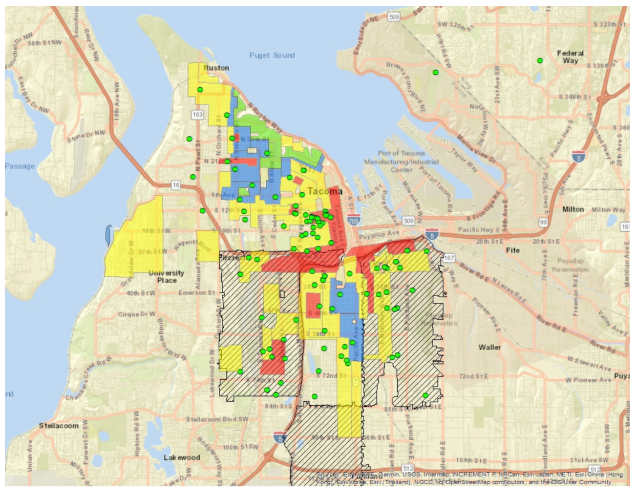
Figure 1 Map of Tacoma
Data gathered through GIS mapping outlines the correlation of trees and historically redlined districts in Tacoma. Areas in red/yellow were lower priority for public investment according to redlining practices. Today, these areas have less tree coverage. The lower number of green dots represents the significant tree coverage points. Cross-hatched areas (in black) are “Communities of focus” determined by Tacoma-Pierce County Health Department due to their low public health outcomes. (Wyse, 2024).
Trees in an urban setting are critical means of reducing environmental risks, such as excessive heat, which is critical given increasing global temperatures. However, trees can also be essential in affecting and reflecting social issues. Street trees, in particular, can serve a role in urban design and facilitate a sense of place. The impact of trees is not felt equally in urban settings, due to various historical practices including redlining. Developed in the 1930s, the system of redlining was created by the Federal Housing Administration, aimed at organizing communities to aid in inexpensive mortgages. Neighborhoods were categorized based on discriminatory factors including race, class, and ethnic composition. This inherently denied the social growth of people of color by limiting access to financial services. Considering historical practices aligned with urban areas, the placement of street trees has grown to integrate environmental justice, and develop tree policies in relation to historical policies.
While research about urban tree canopy is monitored by urban forestry and city planners, research addressing visual differences hasn’t been studied in as much depth, and can serve as a partner to quantitative data analysis. Photos in particular allow for documenting how people interact with trees, and can ensure community voices are present in policy and research.
What is the tool?
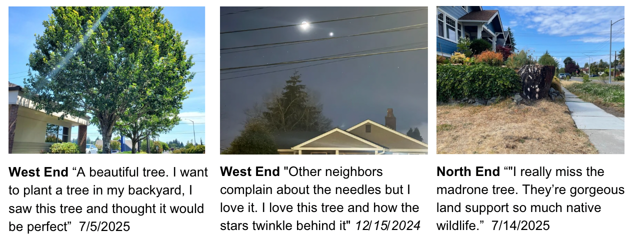
The tool itself explores two main visual elements, comparative street photos and community submissions. Comparative street photos were taken throughout the course of the summer, with over 100 photos of unique locations to provide visual documentation of what it’s like to walk down a street in Tacoma. While there was a clear visual difference among streets in unique redlined districts, other factors are significant to note, such as the expense of caring for trees and ensuring a healthy well pruned tree.
A major part of the project included submissions from you, the community! The prompt was simple: Send a photo of a tree on a street, or a street where you wish there was a tree. The photos submitted through the survey varied in location, detail, and description. However, descriptions often included personal stories and significance. If you want to submit a photo utilize the form here, or email treesoftacoma@gmail.com
I encourage you to explore this tool, as it builds on Tacoma Tree Foundation’s work of tree equity, and environmental justice research.
Explore the photos of your neighborhood and compare them to other places around Tacoma. Ask yourself: How does my street compare to my neighbor’s? What spaces would be drawn to take a walk down?
The project is scheduled to continue. If you have any ideas, comments, or want to contribute photos, or contribute to the project, please reach out to me. Soon, we’ll be experiencing the change of the Tacoma Tree Foundation’s tree planting and care efforts!